Seddon night lights from space
Night Light of Seddon (Victoria) from space (Australia) Src. Average luminocity for 10x10km area is 97.3571% and for 50x50km: 51.4777%.
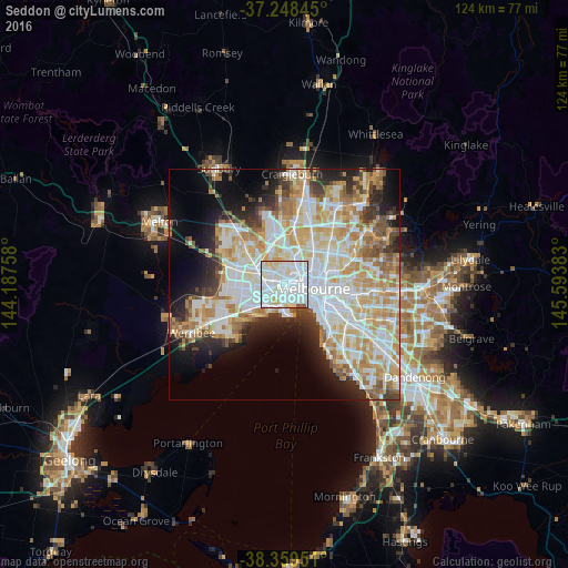
Analysis of Seddon night lights 2016
Square area 10x10 km:
 56.46%
90-99
34.35%80-89
7.14%70-79
1.02%60-69
0%50-59
1.02%40-49
0%30-39
0%20-29
0%10-19
0%0-9
0%Square area 50x50 km:
14.15%90-99
13.04%80-89
6.72%70-79
8.78%60-69
6.23%50-59
4.3%40-49
3.47%30-39
3.53%20-29
6.11%10-19
8.92%0-9
24.73%Clear (daylight) street map image can be seen on geolist.org.
Map coordinates:
37° 14' 54.4" South, 144° 11' 15.3" East
37° 48' 21.9" South, 144° 53' 26.5" East
38° 21' 34.2" South, 145° 35' 37.8" East
Some cities around Seddon sort by population:
• Footscray
1.1 km =0.7 mi,  50°
50°
• Yarraville
1.4 km =0.9 mi,  145°
145°
• Maribyrnong
3.8 km =2.4 mi,  351°
351°
• West Footscray
1.5 km =0.9 mi,  309°
309°
• Kensington
3.9 km =2.4 mi,  66°
66°
• Braybrook
3.8 km =2.4 mi,  304°
304°
• Maidstone
3.2 km =2 mi,  332°
332°
• Flemington
4 km =2.5 mi,  60°
60°
9972582 (p: 5,048)
Sources (retrieved 2019-11-25):
» Earth at Night: Flat Maps 2012, 2016