Williamstown night lights from space
Night Light of Williamstown (Victoria) from space (Australia) Src. Average luminocity for 10x10km area is 58.6315% and for 50x50km: 49.39%.
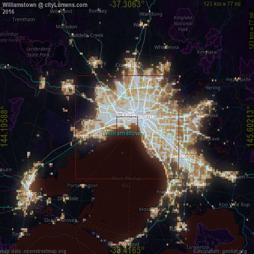
Analysis of Williamstown night lights 2016
Square area 10x10 km:
 25%
25%90-99
14.77%80-89
3.41%70-79
2.27%60-69
1.46%50-59
3.57%40-49
3.9%30-39
10.39%20-29
16.07%10-19
16.72%0-9
2.44%Square area 50x50 km:
14.1%90-99
12.73%80-89
6.74%70-79
8.2%60-69
5.96%50-59
3.79%40-49
2.98%30-39
3.3%20-29
5.16%10-19
7.5%0-9
29.54%Clear (daylight) street map image can be seen on geolist.org.
Map coordinates:
37° 18' 22.7" South, 144° 11' 45.2" East
37° 51' 48.6" South, 144° 53' 56.4" East
38° 24' 59.4" South, 145° 36' 7.7" East
Some cities around Williamstown sort by population:
• Port Melbourne
4.6 km =2.9 mi,  55°
55°
• Yarraville
5.2 km =3.2 mi,  0°
0°
• Newport
2.5 km =1.6 mi,  329°
329°
• Altona North
5.5 km =3.4 mi,  305°
305°
• South Melbourne
6.8 km =4.2 mi, 60°
• Altona
6.1 km =3.8 mi,  263°
263°
• Albert Park
5.3 km =3.3 mi, 61°
• Seddon
6.4 km =4 mi,  353°
353°
2143561 (p: 13,869)
Sources (retrieved 2019-11-25):
» Earth at Night: Flat Maps 2012, 2016