Oberwart night lights from space
Night Light of Oberwart (Burgenland) from space (Austria) Src. Average luminocity for 10x10km area is 5.9301% and for 50x50km: 1.3488%.
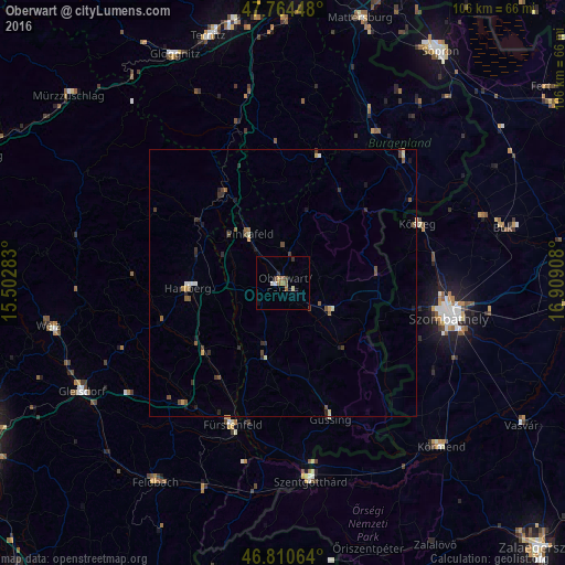
Analysis of Oberwart night lights 2016
Square area 10x10 km:
 0.6%
0.6%90-99
0.6%80-89
0.6%70-79
0.6%60-69
1.34%50-59
1.34%40-49
0.89%30-39
1.34%20-29
0.6%10-19
0.6%0-9
91.52%Square area 50x50 km:
0.06%90-99
0.15%80-89
0.16%70-79
0.15%60-69
0.12%50-59
0.36%40-49
0.4%30-39
0.29%20-29
0.34%10-19
0.31%0-9
97.68%Clear (daylight) street map image can be seen on geolist.org.
Map coordinates:
47° 45' 52.1" North, 15° 30' 10.2" East
47° 17' 23" North, 16° 12' 21.4" East
46° 48' 38.3" North, 16° 54' 32.7" East
Some cities around Oberwart sort by population:
• Szombathely, HU
32 km =19.9 mi,  101°
101°
• Körmend, HU
43.3 km =26.9 mi,  135°
135°
• Kőszeg, HU
27.6 km =17.1 mi,  66°
66°
• Weiz
45.2 km =28.1 mi,  259°
259°
• Szentgotthárd, HU
37.8 km =23.5 mi,  172°
172°
• Gleisdorf
42.7 km =26.5 mi,  241°
241°
• Fürstenfeld
28.2 km =17.5 mi,  199°
199°
• Pinkafeld
10.9 km =6.8 mi,  321°
321°
2769623 (p: 7,288)
Sources (retrieved 2019-11-25):
» Earth at Night: Flat Maps 2012, 2016