Fürstenfeld night lights from space
Night Light of Fürstenfeld (Styria) from space (Austria) Src. Average luminocity for 10x10km area is 5.7514% and for 50x50km: 1.4414%.
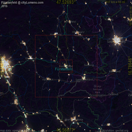
Analysis of Fürstenfeld night lights 2016
Square area 10x10 km:
 0.43%
0.43%90-99
0.71%80-89
0.99%70-79
1.7%60-69
0.71%50-59
0%40-49
0.57%30-39
1.14%20-29
0.57%10-19
0.57%0-9
92.61%Square area 50x50 km:
0.03%90-99
0.18%80-89
0.16%70-79
0.25%60-69
0.19%50-59
0.26%40-49
0.39%30-39
0.26%20-29
0.28%10-19
0.28%0-9
97.72%Clear (daylight) street map image can be seen on geolist.org.
Map coordinates:
47° 31' 36.9" North, 15° 22' 48.8" East
47° 3' 0" North, 16° 4' 60" East
46° 34' 7.6" North, 16° 47' 11.3" East
Some cities around Fürstenfeld sort by population:
• Szentgotthárd, HU
18 km =11.2 mi,  126°
126°
• Oberwart
28.2 km =17.5 mi,  19°
19°
• Gleisdorf
28.9 km =18 mi,  282°
282°
• Grad, SI
27.8 km =17.3 mi,  177°
177°
• Šalovci, SI
29.9 km =18.6 mi,  146°
146°
• Gornji Petrovci, SI
29.2 km =18.1 mi,  158°
158°
• Kuzma, SI
23.7 km =14.7 mi, 180°
• Rogašovci, SI
28.1 km =17.5 mi,  187°
187°
2779115 (p: 6,327)
Sources (retrieved 2019-11-25):
» Earth at Night: Flat Maps 2012, 2016