Körmend night lights from space
Night Light of Körmend (Vas) from space (Hungary) Src. Average luminocity for 10x10km area is 4.8722% and for 50x50km: 2.6518%.
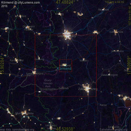
Analysis of Körmend night lights 2016
Square area 10x10 km:
 0.28%
0.28%90-99
0.85%80-89
0.57%70-79
1.7%60-69
0.57%50-59
0%40-49
1.14%30-39
0%20-29
1.14%10-19
0.57%0-9
93.18%Square area 50x50 km:
0.37%90-99
0.5%80-89
0.28%70-79
0.23%60-69
0.3%50-59
0.25%40-49
0.29%30-39
0.28%20-29
0.76%10-19
2.14%0-9
94.61%Clear (daylight) street map image can be seen on geolist.org.
Map coordinates:
47° 29' 17.7" North, 15° 54' 10.2" East
47° 0' 39.5" North, 16° 36' 21.5" East
46° 31' 45.8" North, 17° 18' 32.7" East
Some cities around Körmend sort by population:
• Szombathely
24.5 km =15.2 mi,  2°
2°
• Zalaegerszeg
26.2 km =16.3 mi,  136°
136°
• Sárvár
36.7 km =22.8 mi,  42°
42°
• Szentgotthárd
26 km =16.2 mi,  255°
255°
• Zalaszentgrót
36.7 km =22.8 mi,  101°
101°
• Šalovci, SI
31.2 km =19.4 mi,  228°
228°
• Gornji Petrovci, SI
37 km =23 mi, 231°
• Hodoš, SI
29.3 km =18.2 mi,  224°
224°
3049430 (p: 12,368)
Sources (retrieved 2019-11-25):
» Earth at Night: Flat Maps 2012, 2016