Szentgotthárd night lights from space
Night Light of Szentgotthárd (Vas) from space (Hungary) Src. Average luminocity for 10x10km area is 7.3409% and for 50x50km: 1.1567%.
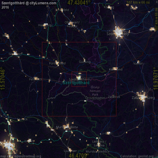
Analysis of Szentgotthárd night lights 2016
Square area 10x10 km:
 0.28%
0.28%90-99
1.7%80-89
1.42%70-79
1.14%60-69
0.57%50-59
0.57%40-49
1.7%30-39
0.57%20-29
0.57%10-19
0.57%0-9
90.91%Square area 50x50 km:
0.04%90-99
0.22%80-89
0.16%70-79
0.25%60-69
0.1%50-59
0.04%40-49
0.28%30-39
0.2%20-29
0.25%10-19
0.22%0-9
98.24%Clear (daylight) street map image can be seen on geolist.org.
Map coordinates:
47° 25' 49.5" North, 15° 34' 13.7" East
46° 57' 9.4" North, 16° 16' 24.9" East
46° 28' 13.8" North, 16° 58' 36.2" East
Some cities around Szentgotthárd sort by population:
• Körmend
26 km =16.2 mi,  75°
75°
• Fürstenfeld, AT
18 km =11.2 mi,  306°
306°
• Grad, SI
21.5 km =13.4 mi,  217°
217°
• Šalovci, SI
14.3 km =8.9 mi,  172°
172°
• Gornji Petrovci, SI
16.8 km =10.4 mi,  193°
193°
• Kuzma, SI
19.3 km =12 mi,  228°
228°
• Rogašovci, SI
24.9 km =15.5 mi, 227°
• Hodoš, SI
15.1 km =9.4 mi,  162°
162°
3044669 (p: 8,911)
Sources (retrieved 2019-11-25):
» Earth at Night: Flat Maps 2012, 2016