Malvinas Argentinas night lights from space
Night Light of Malvinas Argentinas (Cordoba) from space (Argentina) Src. Average luminocity for 10x10km area is 36.1127% and for 50x50km: 24.3431%.
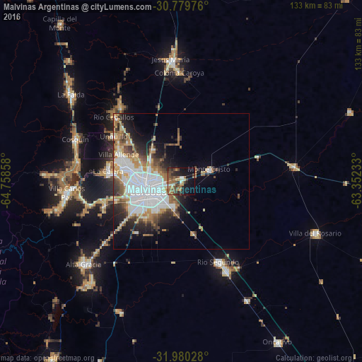
Analysis of Malvinas Argentinas night lights 2016
Square area 10x10 km:
 1.45%
1.45%90-99
3.64%80-89
3.09%70-79
5.64%60-69
9.09%50-59
8.91%40-49
10.18%30-39
5.82%20-29
11.09%10-19
25.45%0-9
15.64%Square area 50x50 km:
7.6%90-99
4.18%80-89
2.49%70-79
2.75%60-69
3.57%50-59
2.11%40-49
3.02%30-39
2.86%20-29
4.02%10-19
6.73%0-9
60.65%Clear (daylight) street map image can be seen on geolist.org.
Map coordinates:
30° 46' 47.1" South, 64° 45' 30.9" West
31° 22' 55" South, 64° 3' 19.6" West
31° 58' 49" South, 63° 21' 8.4" West
Some cities around Malvinas Argentinas sort by population:
• Córdoba
12.4 km =7.7 mi,  253°
253°
• La Calera
26.9 km =16.7 mi,  279°
279°
• Villa Allende
24.8 km =15.4 mi,  293°
293°
• Río Segundo
33.1 km =20.6 mi,  155°
155°
• Río Ceballos
35 km =21.7 mi,  313°
313°
• Unquillo
29.9 km =18.6 mi,  304°
304°
• Malagueño
30.2 km =18.8 mi, 252°
• Monte Cristo
11.4 km =7.1 mi,  67°
67°
3845073 (p: 8,628)
Sources (retrieved 2019-11-25):
» Earth at Night: Flat Maps 2012, 2016