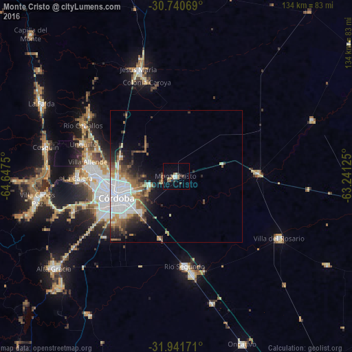
Monte Cristo night lights from space
Night Light of Monte Cristo (Cordoba) from space (Argentina) Src. Average luminocity for 10x10km area is 14.0945% and for 50x50km: 12.917%.
Analysis of Monte Cristo night lights 2016
Square area 10x10 km:
 1.27%
1.27%90-99
2.36%80-89
1.64%70-79
0.55%60-69
2.36%50-59
2.36%40-49
1.64%30-39
2.36%20-29
1.64%10-19
5.27%0-9
78.55%Square area 50x50 km:
4.32%90-99
1.71%80-89
0.82%70-79
1.23%60-69
2.23%50-59
1.31%40-49
1.88%30-39
1.68%20-29
2.23%10-19
4.29%0-9
78.3%Clear (daylight) street map image can be seen on geolist.org.
Map coordinates:
30° 44' 26.5" South, 64° 38' 51" West
31° 20' 35.2" South, 63° 56' 39.7" West
31° 56' 30.2" South, 63° 14' 28.5" West
Some cities around Monte Cristo sort by population:
• Córdoba
23.8 km =14.8 mi,  250°
250°
• La Calera
37.1 km =23.1 mi,  269°
269°
• Villa Allende
33.8 km =21 mi,  279°
279°
• Río Segundo
34.6 km =21.5 mi,  174°
174°
• Unquillo
37.5 km =23.3 mi,  289°
289°
• Pilar
37.8 km =23.5 mi, 170°
• Malvinas Argentinas
11.4 km =7.1 mi, 247°
• Salsipuedes
40.5 km =25.2 mi,  304°
304°
3843871 (p: 6,914)
Sources (retrieved 2019-11-25):
» Earth at Night: Flat Maps 2012, 2016