Unquillo night lights from space
Night Light of Unquillo (Cordoba) from space (Argentina) Src. Average luminocity for 10x10km area is 43.0686% and for 50x50km: 28.7323%.
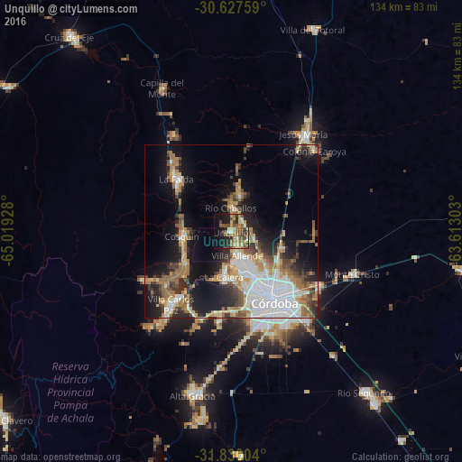
Analysis of Unquillo night lights 2016
Square area 10x10 km:
 0.95%
0.95%90-99
4.95%80-89
8.19%70-79
7.81%60-69
10.86%50-59
6.86%40-49
12.57%30-39
4.38%20-29
14.1%10-19
18.67%0-9
10.67%Square area 50x50 km:
7.12%90-99
4.12%80-89
3.16%70-79
3.24%60-69
5.32%50-59
3.4%40-49
3.33%30-39
3.84%20-29
5.95%10-19
14.19%0-9
46.33%Clear (daylight) street map image can be seen on geolist.org.
Map coordinates:
30° 37' 39.3" South, 65° 1' 9.4" West
31° 13' 50.6" South, 64° 18' 58.1" West
31° 49' 48.1" South, 63° 36' 46.9" West
Some cities around Unquillo sort by population:
• Córdoba
24 km =14.9 mi,  147°
147°
• La Calera
12.7 km =7.9 mi,  188°
188°
• Villa Allende
7.4 km =4.6 mi,  164°
164°
• Cosquín
14.3 km =8.9 mi,  263°
263°
• Río Ceballos
7.3 km =4.5 mi,  355°
355°
• La Falda
22.9 km =14.2 mi,  313°
313°
• Salsipuedes
10.6 km =6.6 mi,  10°
10°
• Valle Hermoso
20.1 km =12.5 mi, 308°
3833412 (p: 15,369)
Sources (retrieved 2019-11-25):
» Earth at Night: Flat Maps 2012, 2016