Río Ceballos night lights from space
Night Light of Río Ceballos (Cordoba) from space (Argentina) Src. Average luminocity for 10x10km area is 31.7051% and for 50x50km: 21.2609%.
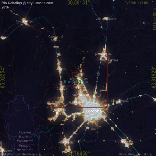
Analysis of Río Ceballos night lights 2016
Square area 10x10 km:
 0.55%
0.55%90-99
2.56%80-89
3.11%70-79
7.33%60-69
9.89%50-59
4.03%40-49
5.68%30-39
7.14%20-29
9.16%10-19
27.47%0-9
23.08%Square area 50x50 km:
3.63%90-99
2.86%80-89
2.33%70-79
2.73%60-69
4.71%50-59
2.6%40-49
3.01%30-39
3.19%20-29
4.45%10-19
12.63%0-9
57.87%Clear (daylight) street map image can be seen on geolist.org.
Map coordinates:
30° 33' 40.7" South, 65° 1' 31.9" West
31° 9' 53.5" South, 64° 19' 20.7" West
31° 45' 52.5" South, 63° 37' 9.4" West
Some cities around Río Ceballos sort by population:
• La Calera
19.9 km =12.4 mi,  183°
183°
• Villa Allende
14.7 km =9.1 mi,  169°
169°
• Cosquín
16.3 km =10.1 mi,  236°
236°
• Unquillo
7.3 km =4.5 mi, 175°
• La Falda
18.1 km =11.2 mi,  298°
298°
• Salsipuedes
4 km =2.5 mi,  39°
39°
• Huerta Grande
18.9 km =11.7 mi, 301°
• Valle Hermoso
16 km =9.9 mi,  289°
289°
3838902 (p: 16,632)
Sources (retrieved 2019-11-25):
» Earth at Night: Flat Maps 2012, 2016