Malagueño night lights from space
Night Light of Malagueño (Cordoba) from space (Argentina) Src. Average luminocity for 10x10km area is 34.6941% and for 50x50km: 31.5307%.
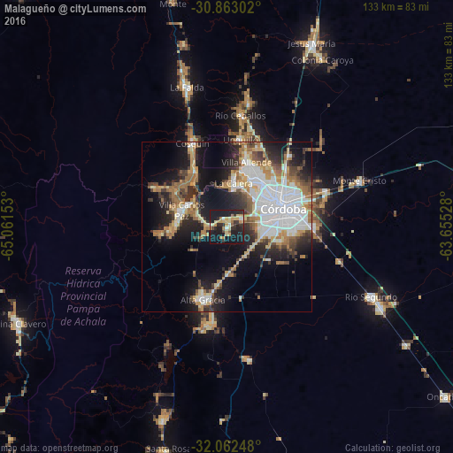
Analysis of Malagueño night lights 2016
Square area 10x10 km:
 1.75%
1.75%90-99
2.62%80-89
9.27%70-79
6.64%60-69
4.02%50-59
2.1%40-49
1.57%30-39
6.29%20-29
14.51%10-19
48.6%0-9
2.62%Square area 50x50 km:
8.19%90-99
4.86%80-89
3.78%70-79
3.49%60-69
5.08%50-59
2.81%40-49
3.56%30-39
4.39%20-29
7.16%10-19
15.87%0-9
40.81%Clear (daylight) street map image can be seen on geolist.org.
Map coordinates:
30° 51' 46.9" South, 65° 3' 41.5" West
31° 27' 52.8" South, 64° 21' 30.2" West
32° 3' 44.9" South, 63° 39' 19" West
Some cities around Malagueño sort by population:
• Córdoba
17.8 km =11.1 mi,  71°
71°
• Villa Carlos Paz
14 km =8.7 mi,  288°
288°
• Alta Gracia
22 km =13.7 mi,  197°
197°
• La Calera
13.6 km =8.5 mi,  9°
9°
• Villa Allende
19.8 km =12.3 mi,  17°
17°
• Cosquín
26.5 km =16.5 mi,  337°
337°
• Unquillo
26.3 km =16.3 mi, 8°
• Malvinas Argentinas
30.2 km =18.8 mi, 72°
3845202 (p: 9,364)
Sources (retrieved 2019-11-25):
» Earth at Night: Flat Maps 2012, 2016