Ḩukūmatī Azrah night lights from space
Night Light of Ḩukūmatī Azrah (Logar) from space (Afghanistan) Src. Average luminocity for 10x10km area is 0% and for 50x50km: 0%.
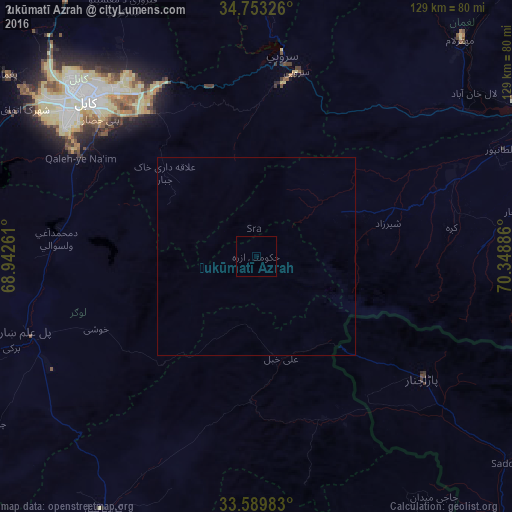
Analysis of Ḩukūmatī Azrah night lights 2016
Square area 10x10 km:
 0%
0%90-99
0%80-89
0%70-79
0%60-69
0%50-59
0%40-49
0%30-39
0%20-29
0%10-19
0%0-9
100%Square area 50x50 km:
0%90-99
0%80-89
0%70-79
0%60-69
0%50-59
0%40-49
0%30-39
0%20-29
0%10-19
0%0-9
100%Clear (daylight) street map image can be seen on geolist.org.
Map coordinates:
34° 45' 11.7" North, 68° 56' 33.4" East
34° 10' 24.8" North, 69° 38' 44.6" East
33° 35' 23.4" North, 70° 20' 55.9" East
Some cities around Ḩukūmatī Azrah sort by population:
• Kabul
58.7 km =36.5 mi,  312°
312°
• Gardez
74.9 km =46.5 mi,  211°
211°
• Baraki Barak
68.1 km =42.3 mi,  250°
250°
• Mehtar Lām
75.7 km =47 mi,  43°
43°
• Pul-e ‘Alam
60.7 km =37.7 mi, 250°
• Tagāb
75.8 km =47.1 mi,  0°
0°
• Maydanshakhr
75.8 km =47.1 mi,  289°
289°
• Parachinar, PK
51.8 km =32.2 mi,  126°
126°
1147851 (p: 12,526)
Sources (retrieved 2019-11-25):
» Earth at Night: Flat Maps 2012, 2016