Nakambala night lights from space
Night Light of Nakambala (Southern) from space (Zambia) Src. Average luminocity for 10x10km area is 30.2987% and for 50x50km: 1.9001%.
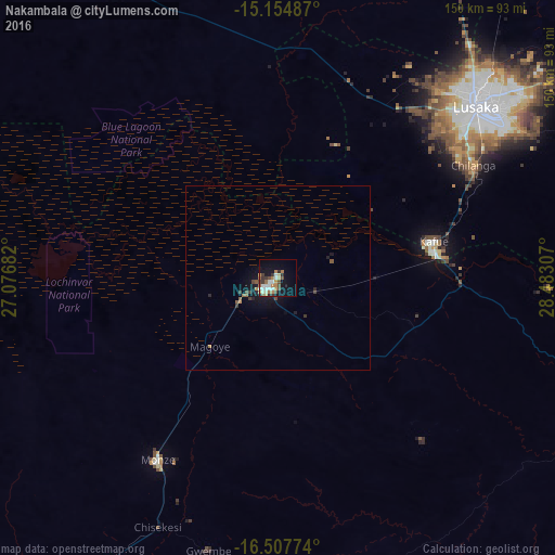
Analysis of Nakambala night lights 2016
Square area 10x10 km:
 4.33%
4.33%90-99
6.71%80-89
2.38%70-79
4.76%60-69
5.41%50-59
1.73%40-49
5.19%30-39
5.84%20-29
0.87%10-19
20.56%0-9
42.21%Square area 50x50 km:
0.17%90-99
0.26%80-89
0.09%70-79
0.28%60-69
0.29%50-59
0.28%40-49
0.34%30-39
0.41%20-29
0.19%10-19
1.84%0-9
95.86%Clear (daylight) street map image can be seen on geolist.org.
Map coordinates:
15° 9' 17.5" South, 27° 4' 36.6" East
15° 49' 56.8" South, 27° 46' 47.8" East
16° 30' 27.9" South, 28° 28' 59.1" East
Some cities around Nakambala sort by population:
• Lusaka
72 km =44.7 mi,  48°
48°
• Mazabuka
4.3 km =2.7 mi,  232°
232°
• Kafue
43.5 km =27 mi,  80°
80°
• Monze
59.3 km =36.8 mi,  212°
212°
• Kariba, ZW
132.9 km =82.6 mi,  124°
124°
• Mumbwa
121.8 km =75.7 mi,  320°
320°
• Siavonga
126.5 km =78.6 mi,  128°
128°
• Chongwe
111.7 km =69.4 mi,  59°
59°
902344 (p: 10,425)
Sources (retrieved 2019-11-25):
» Earth at Night: Flat Maps 2012, 2016