Thabazimbi night lights from space
Night Light of Thabazimbi (Limpopo) from space (South Africa) Src. Average luminocity for 10x10km area is 16.871% and for 50x50km: 1.4469%.
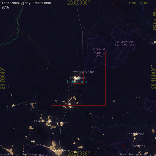
Analysis of Thabazimbi night lights 2016
Square area 10x10 km:
 1.59%
1.59%90-99
0.79%80-89
2.98%70-79
3.77%60-69
4.56%50-59
2.18%40-49
1.59%30-39
0.6%20-29
3.37%10-19
1.19%0-9
77.38%Square area 50x50 km:
0.1%90-99
0.06%80-89
0.17%70-79
0.32%60-69
0.26%50-59
0.18%40-49
0.28%30-39
0.13%20-29
0.33%10-19
0.24%0-9
97.92%Clear (daylight) street map image can be seen on geolist.org.
Map coordinates:
23° 57' 2.4" South, 26° 42' 30.3" East
24° 35' 29.9" South, 27° 24' 41.6" East
25° 13' 45.7" South, 28° 6' 52.8" East
Some cities around Thabazimbi sort by population:
• Rustenburg
120.8 km =75.1 mi,  188°
188°
• Brits
121.8 km =75.7 mi,  162°
162°
• Mabopane
122.3 km =76 mi,  145°
145°
• Warmbaths
93.8 km =58.3 mi,  110°
110°
• Ga-Rankuwa
128.2 km =79.7 mi, 152°
• Mochudi, BW
129.1 km =80.2 mi,  278°
278°
• Modimolle
100.6 km =62.5 mi,  96°
96°
• Maile
95.4 km =59.3 mi, 187°
949683 (p: 10,365)
Sources (retrieved 2019-11-25):
» Earth at Night: Flat Maps 2012, 2016