Maile night lights from space
Night Light of Maile (North-West) from space (South Africa) Src. Average luminocity for 10x10km area is 9.4782% and for 50x50km: 18.7063%.
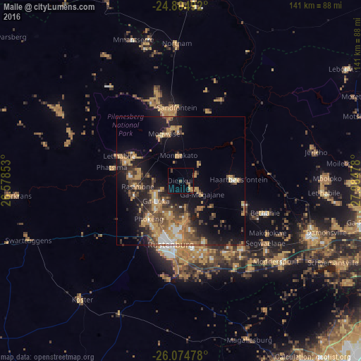
Analysis of Maile night lights 2016
Square area 10x10 km:
 0%
0%90-99
0%80-89
0.79%70-79
3.17%60-69
0%50-59
1.19%40-49
3.97%30-39
0.6%20-29
0.99%10-19
3.37%0-9
85.91%Square area 50x50 km:
1.19%90-99
1.52%80-89
1.72%70-79
5.21%60-69
3.56%50-59
2.35%40-49
4.2%30-39
3.04%20-29
5.05%10-19
11.93%0-9
60.23%Clear (daylight) street map image can be seen on geolist.org.
Map coordinates:
24° 48' 17.7" South, 26° 34' 42.7" East
25° 26' 29.5" South, 27° 16' 53.9" East
26° 4' 29.2" South, 27° 59' 5.2" East
Some cities around Maile sort by population:
• Krugersdorp
87 km =54.1 mi,  145°
145°
• Diepsloot
91.4 km =56.8 mi,  126°
126°
• Randfontein
92.7 km =57.6 mi, 153°
• Rustenburg
25.4 km =15.8 mi,  188°
188°
• Brits
54.4 km =33.8 mi,  113°
113°
• Mabopane
82.5 km =51.3 mi,  94°
94°
• Ga-Rankuwa
74.2 km =46.1 mi, 105°
• Koster
60.6 km =37.7 mi,  219°
219°
980213 (p: 10,000)
Sources (retrieved 2019-11-25):
» Earth at Night: Flat Maps 2012, 2016