Ladybrand night lights from space
Night Light of Ladybrand (Orange Free State) from space (South Africa) Src. Average luminocity for 10x10km area is 12.5813% and for 50x50km: 4.7456%.
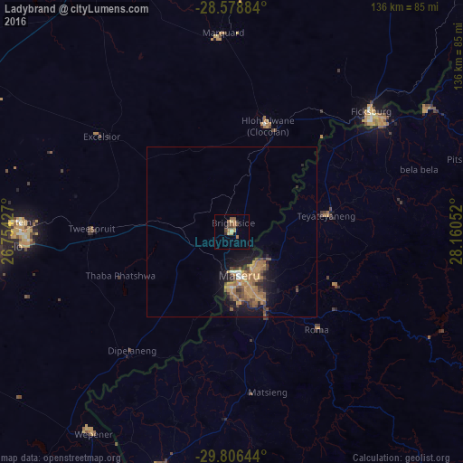
Analysis of Ladybrand night lights 2016
Square area 10x10 km:
 0%
0%90-99
0.2%80-89
2.98%70-79
1.59%60-69
3.17%50-59
3.37%40-49
2.78%30-39
1.79%20-29
1.59%10-19
0%0-9
82.54%Square area 50x50 km:
0.17%90-99
0.16%80-89
0.22%70-79
1.47%60-69
1.38%50-59
0.9%40-49
0.95%30-39
0.62%20-29
1%10-19
3.29%0-9
89.83%Clear (daylight) street map image can be seen on geolist.org.
Map coordinates:
28° 34' 43.8" South, 26° 45' 15.4" East
29° 11' 40.1" South, 27° 27' 26.6" East
29° 48' 23.2" South, 28° 9' 37.9" East
Some cities around Ladybrand sort by population:
• Maseru, LS
13.8 km =8.6 mi,  169°
169°
• Leribe, LS
67.5 km =41.9 mi,  57°
57°
• Thaba Nchu
60 km =37.3 mi,  268°
268°
• Maputsoe, LS
54.9 km =34.1 mi,  51°
51°
• Nako, LS
55.7 km =34.6 mi,  147°
147°
• Clocolan
32.9 km =20.4 mi,  18°
18°
• Marquard
59 km =36.7 mi,  357°
357°
• Teyateyaneng, LS
28.8 km =17.9 mi,  79°
79°
985015 (p: 17,228)
Sources (retrieved 2019-11-25):
» Earth at Night: Flat Maps 2012, 2016