Marquard night lights from space
Night Light of Marquard (Orange Free State) from space (South Africa) Src. Average luminocity for 10x10km area is 6.0473% and for 50x50km: 0.2912%.
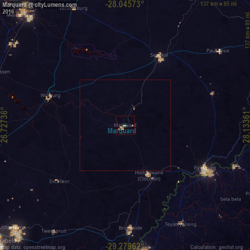
Analysis of Marquard night lights 2016
Square area 10x10 km:
 0%
0%90-99
0%80-89
0.76%70-79
4.17%60-69
1.14%50-59
0%40-49
0.57%30-39
0.95%20-29
0%10-19
0.76%0-9
91.67%Square area 50x50 km:
0%90-99
0%80-89
0.03%70-79
0.16%60-69
0.07%50-59
0%40-49
0.02%30-39
0.04%20-29
0.04%10-19
0.05%0-9
99.58%Clear (daylight) street map image can be seen on geolist.org.
Map coordinates:
28° 2' 44.6" South, 26° 43' 38.5" East
28° 39' 52.2" South, 27° 25' 49.7" East
29° 16' 46.6" South, 28° 8' 1" East
Some cities around Marquard sort by population:
• Leribe, LS
64.2 km =39.9 mi,  111°
111°
• Senekal
42.6 km =26.5 mi,  25°
25°
• Maputsoe, LS
51.9 km =32.2 mi,  118°
118°
• Ladybrand
59 km =36.7 mi,  177°
177°
• Clocolan
30.7 km =19.1 mi,  154°
154°
• Winburg
44.2 km =27.5 mi,  291°
291°
• Ventersburg
70.4 km =43.7 mi,  336°
336°
• Teyateyaneng, LS
62 km =38.5 mi, 149°
978677 (p: 10,839)
Sources (retrieved 2019-11-25):
» Earth at Night: Flat Maps 2012, 2016