Kriel night lights from space
Night Light of Kriel (Mpumalanga) from space (South Africa) Src. Average luminocity for 10x10km area is 16.7044% and for 50x50km: 10.8073%.
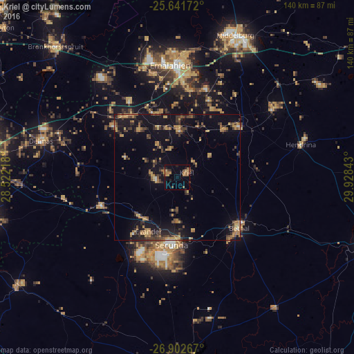
Analysis of Kriel night lights 2016
Square area 10x10 km:
 0%
0%90-99
0%80-89
1.79%70-79
3.37%60-69
7.74%50-59
1.39%40-49
3.37%30-39
1.39%20-29
2.18%10-19
3.77%0-9
75%Square area 50x50 km:
0.15%90-99
0.21%80-89
1.42%70-79
2.22%60-69
2.12%50-59
1.12%40-49
2.63%30-39
2.07%20-29
2.96%10-19
9.98%0-9
75.13%Clear (daylight) street map image can be seen on geolist.org.
Map coordinates:
25° 38' 30.2" South, 28° 31' 19.8" East
26° 16' 26.1" South, 29° 13' 31.1" East
26° 54' 9.6" South, 29° 55' 42.3" East
Some cities around Kriel sort by population:
• Witbank
44.8 km =27.8 mi,  1°
1°
• Middelburg
60.4 km =37.5 mi,  23°
23°
• eMbalenhle
32.9 km =20.4 mi,  208°
208°
• Bethal
31.5 km =19.6 mi,  130°
130°
• Delmas
55.9 km =34.7 mi,  284°
284°
• Bronkhorstspruit
70.6 km =43.9 mi,  316°
316°
• Secunda
31.2 km =19.4 mi,  190°
190°
• Hendrina
50.5 km =31.4 mi,  75°
75°
987202 (p: 15,055)
Sources (retrieved 2019-11-25):
» Earth at Night: Flat Maps 2012, 2016