Christiana night lights from space
Night Light of Christiana (North-West) from space (South Africa) Src. Average luminocity for 10x10km area is 18.4735% and for 50x50km: 0.9994%.
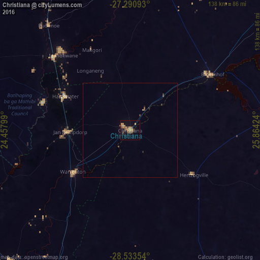
Analysis of Christiana night lights 2016
Square area 10x10 km:
 0.76%
0.76%90-99
0%80-89
0.38%70-79
7.39%60-69
5.87%50-59
1.52%40-49
5.11%30-39
3.22%20-29
1.52%10-19
3.22%0-9
71.02%Square area 50x50 km:
0.03%90-99
0%80-89
0.02%70-79
0.33%60-69
0.24%50-59
0.14%40-49
0.3%30-39
0.18%20-29
0.15%10-19
0.18%0-9
98.42%Clear (daylight) street map image can be seen on geolist.org.
Map coordinates:
27° 17' 27.3" South, 24° 27' 28.8" East
27° 54' 50.5" South, 25° 9' 40" East
28° 32' 0.7" South, 25° 51' 51.3" East
Some cities around Christiana sort by population:
• Kimberley
99 km =61.5 mi,  203°
203°
• Schweizer-Reneke
82.3 km =51.1 mi,  11°
11°
• Pampierstad
48.8 km =30.3 mi,  287°
287°
• Warrenton
38 km =23.6 mi,  234°
234°
• Bloemhof
53 km =32.9 mi,  55°
55°
• Jan Kempdorp
32.5 km =20.2 mi,  268°
268°
• Hoopstad
74 km =46 mi,  82°
82°
• Barkly West
93.3 km =58 mi,  222°
222°
1013550 (p: 17,523)
Sources (retrieved 2019-11-25):
» Earth at Night: Flat Maps 2012, 2016