Dương Đông night lights from space
Night Light of Dương Đông (Kiến Giang) from space (Vietnam) Src. Average luminocity for 10x10km area is 20.2004% and for 50x50km: 1.7791%.
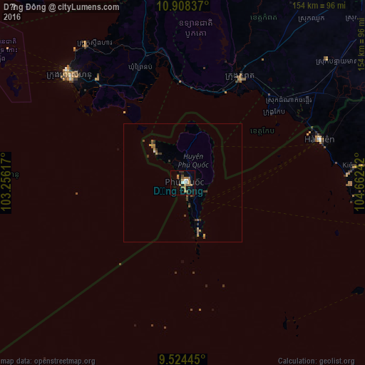
Analysis of Dương Đông night lights 2016
Square area 10x10 km:
 0.83%
0.83%90-99
3.31%80-89
0.21%70-79
5.79%60-69
6.82%50-59
2.07%40-49
0.83%30-39
2.48%20-29
1.03%10-19
8.88%0-9
67.77%Square area 50x50 km:
0.06%90-99
0.14%80-89
0.1%70-79
0.42%60-69
0.4%50-59
0.4%40-49
0.16%30-39
0.44%20-29
0.19%10-19
0.47%0-9
97.23%Clear (daylight) street map image can be seen on geolist.org.
Map coordinates:
10° 54' 30.1" North, 103° 15' 22.2" East
10° 13' 1.8" North, 103° 57' 33.4" East
9° 31' 28" North, 104° 39' 44.7" East
Some cities around Dương Đông sort by population:
• Takeo, KH
124.7 km =77.5 mi,  46°
46°
• Rạch Giá
124.9 km =77.6 mi,  100°
100°
• Sihanoukville, KH
64.1 km =39.8 mi,  312°
312°
• Cho Dok
137.5 km =85.4 mi,  67°
67°
• Phumĭ Véal Srê, KH
123.4 km =76.7 mi, 46°
• Hà Tiên
60.7 km =37.7 mi, 72°
• Kampot, KH
50 km =31.1 mi,  29°
29°
• Krong Kep, KH
49 km =30.4 mi, 52°
1569973 (p: 15,000)
Sources (retrieved 2019-11-25):
» Earth at Night: Flat Maps 2012, 2016