Wobkent night lights from space
Night Light of Wobkent (Bukhara) from space (Uzbekistan) Src. Average luminocity for 10x10km area is 14.724% and for 50x50km: 7.8942%.
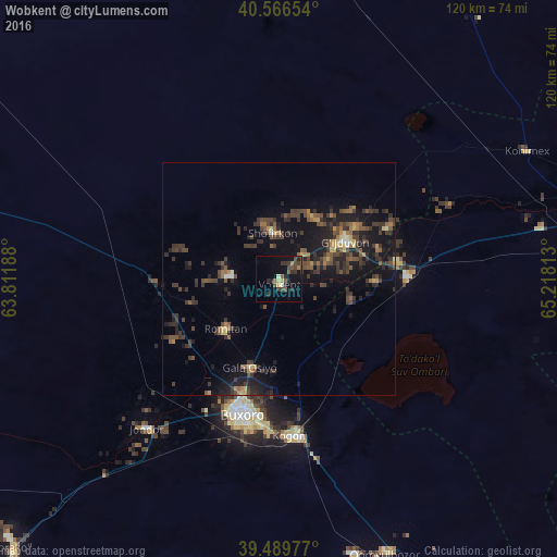
Analysis of Wobkent night lights 2016
Square area 10x10 km:
 0.49%
0.49%90-99
0.49%80-89
1.79%70-79
0.97%60-69
1.79%50-59
2.76%40-49
4.06%30-39
5.68%20-29
5.68%10-19
10.39%0-9
65.91%Square area 50x50 km:
0.1%90-99
0.27%80-89
0.75%70-79
0.56%60-69
1.04%50-59
1.49%40-49
2.22%30-39
3.46%20-29
3.06%10-19
7.58%0-9
79.47%Clear (daylight) street map image can be seen on geolist.org.
Map coordinates:
40° 33' 59.5" North, 63° 48' 42.8" East
40° 1' 49" North, 64° 30' 54" East
39° 29' 23.2" North, 65° 13' 5.3" East
Some cities around Wobkent sort by population:
• Bukhara
29.4 km =18.3 mi,  194°
194°
• Kogon
34.3 km =21.3 mi,  174°
174°
• Ghijduwon
16.3 km =10.1 mi,  61°
61°
• Shofirkon
10 km =6.2 mi,  353°
353°
• Galaosiyo
20 km =12.4 mi,  196°
196°
• Qiziltepa
28.5 km =17.7 mi,  89°
89°
• Romiton
16.1 km =10 mi,  225°
225°
• Qorovulbozor
63.5 km =39.5 mi,  157°
157°
1512423 (p: 16,697)
Sources (retrieved 2019-11-25):
» Earth at Night: Flat Maps 2012, 2016