San Ramón night lights from space
Night Light of San Ramón (Canelones) from space (Uruguay) Src. Average luminocity for 10x10km area is 5.0238% and for 50x50km: 1.5449%.
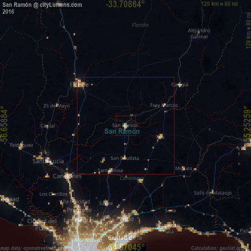
Analysis of San Ramón night lights 2016
Square area 10x10 km:
 0.37%
0.37%90-99
0.37%80-89
0%70-79
2.2%60-69
0%50-59
1.28%40-49
1.65%30-39
0.73%20-29
0%10-19
0.73%0-9
92.67%Square area 50x50 km:
0.01%90-99
0.04%80-89
0.19%70-79
0.64%60-69
0.17%50-59
0.42%40-49
0.22%30-39
0.34%20-29
0.17%10-19
0.17%0-9
97.62%Clear (daylight) street map image can be seen on geolist.org.
Map coordinates:
33° 42' 31.1" South, 56° 39' 31.8" West
34° 17' 29.6" South, 55° 57' 20.6" West
34° 52' 13.6" South, 55° 15' 9.3" West
Some cities around San Ramón sort by population:
• Florida
32.2 km =20 mi,  312°
312°
• Barros Blancos
51.4 km =31.9 mi,  184°
184°
• Pando
47.3 km =29.4 mi, 180°
• Canelones
39.2 km =24.4 mi,  228°
228°
• Santa Lucía
43.8 km =27.2 mi,  245°
245°
• Progreso
48.2 km =30 mi,  209°
209°
• Joaquín Suárez
49.8 km =30.9 mi,  188°
188°
• Sauce
41.3 km =25.7 mi, 193°
3440596 (p: 7,008)
Sources (retrieved 2019-11-25):
» Earth at Night: Flat Maps 2012, 2016