Sauce night lights from space
Night Light of Sauce (Canelones) from space (Uruguay) Src. Average luminocity for 10x10km area is 8.5524% and for 50x50km: 24.451%.
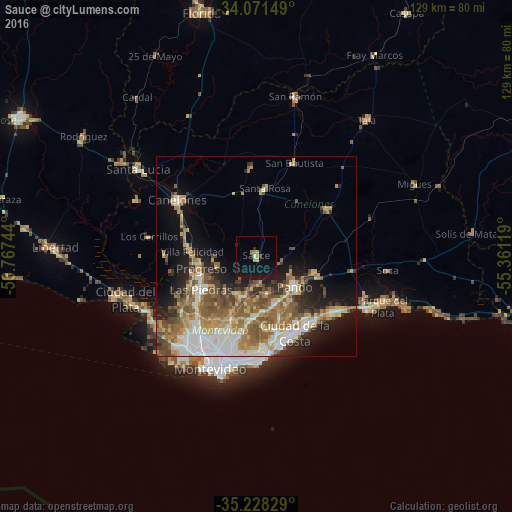
Analysis of Sauce night lights 2016
Square area 10x10 km:
 0.52%
0.52%90-99
0.17%80-89
1.05%70-79
1.22%60-69
1.92%50-59
0%40-49
0%30-39
1.22%20-29
1.05%10-19
14.34%0-9
78.5%Square area 50x50 km:
3.98%90-99
4.01%80-89
3.05%70-79
3.88%60-69
4.45%50-59
5.11%40-49
3.47%30-39
2.5%20-29
4.05%10-19
8.9%0-9
56.59%Clear (daylight) street map image can be seen on geolist.org.
Map coordinates:
34° 4' 17.4" South, 56° 46' 2.8" West
34° 39' 6.9" South, 56° 3' 51.5" West
35° 13' 41.8" South, 55° 21' 40.3" West
Some cities around Sauce sort by population:
• Las Piedras
16.6 km =10.3 mi,  238°
238°
• Barros Blancos
12.5 km =7.8 mi,  153°
153°
• Pando
12.1 km =7.5 mi,  126°
126°
• La Paz
19.1 km =11.9 mi,  230°
230°
• Progreso
14.1 km =8.8 mi,  263°
263°
• Paso de Carrasco
23.2 km =14.4 mi,  177°
177°
• Colonia Nicolich
18.5 km =11.5 mi,  168°
168°
• Joaquín Suárez
9.6 km =6 mi,  163°
163°
3440379 (p: 5,910)
Sources (retrieved 2019-11-25):
» Earth at Night: Flat Maps 2012, 2016