Santa Lucía night lights from space
Night Light of Santa Lucía (Canelones) from space (Uruguay) Src. Average luminocity for 10x10km area is 13.5262% and for 50x50km: 3.8405%.
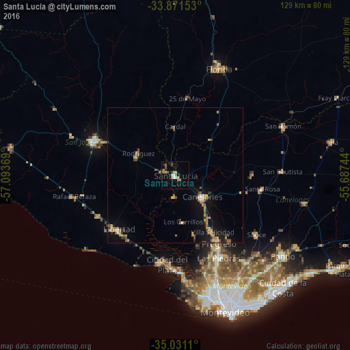
Analysis of Santa Lucía night lights 2016
Square area 10x10 km:
 0.17%
0.17%90-99
2.1%80-89
0.52%70-79
4.2%60-69
2.62%50-59
1.4%40-49
2.27%30-39
0.7%20-29
2.8%10-19
1.22%0-9
81.99%Square area 50x50 km:
0.1%90-99
0.22%80-89
0.5%70-79
0.97%60-69
0.77%50-59
0.56%40-49
0.37%30-39
0.6%20-29
0.51%10-19
2.17%0-9
93.22%Clear (daylight) street map image can be seen on geolist.org.
Map coordinates:
33° 52' 17.5" South, 57° 5' 37.3" West
34° 27' 12" South, 56° 23' 26" West
35° 1' 52" South, 55° 41' 14.8" West
Some cities around Santa Lucía sort by population:
• Las Piedras
34.6 km =21.5 mi,  152°
152°
• San José de Mayo
32.3 km =20.1 mi,  293°
293°
• La Paz
37.3 km =23.2 mi,  156°
156°
• Canelones
12.9 km =8 mi,  126°
126°
• Delta del Tigre
34.7 km =21.6 mi,  176°
176°
• Progreso
28.6 km =17.8 mi, 146°
• Libertad
28.9 km =18 mi,  225°
225°
• Sauce
37.2 km =23.1 mi, 126°
3440571 (p: 16,438)
Sources (retrieved 2019-11-25):
» Earth at Night: Flat Maps 2012, 2016