Canelones night lights from space
Night Light of Canelones from space (Uruguay) Src. Average luminocity for 10x10km area is 16.9668% and for 50x50km: 7.4721%.
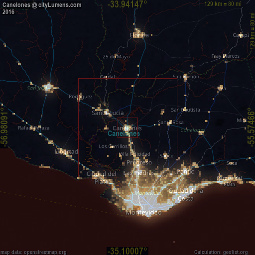
Analysis of Canelones night lights 2016
Square area 10x10 km:
 1.75%
1.75%90-99
1.75%80-89
2.45%70-79
2.45%60-69
4.2%50-59
2.45%40-49
0%30-39
2.1%20-29
0.87%10-19
10.66%0-9
71.33%Square area 50x50 km:
0.36%90-99
0.6%80-89
1%70-79
1.23%60-69
1.31%50-59
1.27%40-49
1.4%30-39
1.57%20-29
1.8%10-19
4.97%0-9
84.47%Clear (daylight) street map image can be seen on geolist.org.
Map coordinates:
33° 56' 29.3" South, 56° 58' 51.3" West
34° 31' 22" South, 56° 16' 40" West
35° 6' 0.3" South, 55° 34' 28.8" West
Some cities around Canelones sort by population:
• Las Piedras
23.7 km =14.7 mi,  166°
166°
• La Paz
26.8 km =16.7 mi, 169°
• Delta del Tigre
28.1 km =17.5 mi,  196°
196°
• Santa Lucía
12.9 km =8 mi,  306°
306°
• Progreso
17 km =10.6 mi,  161°
161°
• Libertad
33.5 km =20.8 mi,  248°
248°
• Joaquín Suárez
32.4 km =20.1 mi,  136°
136°
• Sauce
24.2 km =15 mi,  126°
126°
3443413 (p: 19,698)
Sources (retrieved 2019-11-25):
» Earth at Night: Flat Maps 2012, 2016