Marion night lights from space
Night Light of Marion (Arkansas) from space (United States) Src. Average luminocity for 10x10km area is 47.8322% and for 50x50km: 27.997%.
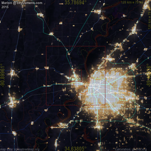
Analysis of Marion night lights 2016
Square area 10x10 km:
 4.37%
4.37%90-99
7.34%80-89
5.59%70-79
8.74%60-69
11.19%50-59
8.92%40-49
6.99%30-39
10.49%20-29
15.21%10-19
17.66%0-9
3.5%Square area 50x50 km:
10.55%90-99
5.64%80-89
2.97%70-79
2.84%60-69
2.61%50-59
2.48%40-49
2.48%30-39
2.92%20-29
3.47%10-19
5.83%0-9
58.2%Clear (daylight) street map image can be seen on geolist.org.
Map coordinates:
35° 47' 13" North, 90° 53' 58.6" West
35° 12' 52.3" North, 90° 11' 47.3" West
34° 38' 17" North, 89° 29' 36.1" West
Some cities around Marion sort by population:
• Memphis
15.2 km =9.4 mi,  118°
118°
• New South Memphis
19.1 km =11.9 mi,  138°
138°
• Bartlett
29.3 km =18.2 mi,  92°
92°
• Southaven
30.1 km =18.7 mi,  146°
146°
• Germantown
37.9 km =23.5 mi,  112°
112°
• Horn Lake
32.4 km =20.1 mi, 152°
• West Memphis
7.6 km =4.7 mi,  171°
171°
• Millington
30.6 km =19 mi,  62°
62°
4120524 (p: 12,292)
Sources (retrieved 2019-11-25):
» Earth at Night: Flat Maps 2012, 2016