Woodside night lights from space
Night Light of Woodside (California) from space (United States) Src. Average luminocity for 10x10km area is 30.6169% and for 50x50km: 28.8945%.
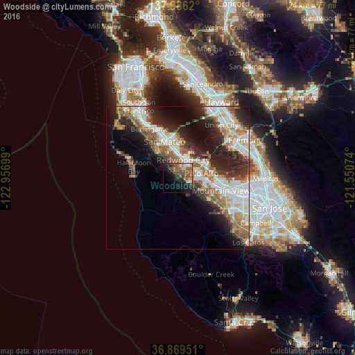
Analysis of Woodside night lights 2016
Square area 10x10 km:
 2.27%
2.27%90-99
2.6%80-89
1.62%70-79
4.71%60-69
6.01%50-59
11.36%40-49
6.98%30-39
4.87%20-29
7.95%10-19
22.08%0-9
29.55%Square area 50x50 km:
6.46%90-99
6.09%80-89
1.72%70-79
3.86%60-69
4.43%50-59
4.69%40-49
3.6%30-39
3.9%20-29
7.09%10-19
9.87%0-9
48.27%Clear (daylight) street map image can be seen on geolist.org.
Map coordinates:
37° 59' 10.3" North, 122° 57' 25.2" West
37° 25' 47.8" North, 122° 15' 13.9" West
36° 52' 10.2" North, 121° 33' 2.7" West
Some cities around Woodside sort by population:
• Redwood City
6.3 km =3.9 mi,  14°
14°
• Palo Alto
9.9 km =6.2 mi,  82°
82°
• Menlo Park
6.9 km =4.3 mi,  67°
67°
• San Carlos
8.6 km =5.3 mi,  356°
356°
• Belmont
10.2 km =6.3 mi,  349°
349°
• North Fair Oaks
7.1 km =4.4 mi,  45°
45°
• Stanford
7.8 km =4.8 mi,  94°
94°
• Atherton
6.1 km =3.8 mi, 54°
5410535 (p: 5,561)
Sources (retrieved 2019-11-25):
» Earth at Night: Flat Maps 2012, 2016