Woodbury night lights from space
Night Light of Woodbury (New York) from space (United States) Src. Average luminocity for 10x10km area is 16.2211% and for 50x50km: 23.1242%.
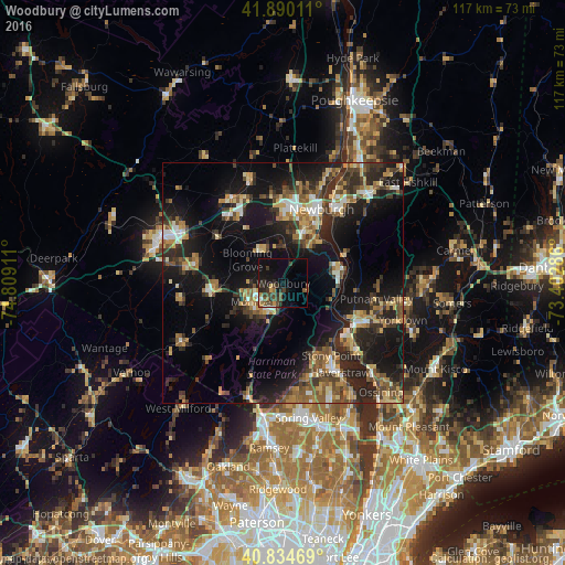
Analysis of Woodbury night lights 2016
Square area 10x10 km:
 0.34%
0.34%90-99
0.34%80-89
0.68%70-79
1.36%60-69
2.72%50-59
2.72%40-49
6.63%30-39
4.93%20-29
6.46%10-19
13.78%0-9
60.03%Square area 50x50 km:
1.73%90-99
2.34%80-89
3.02%70-79
3.15%60-69
3.29%50-59
3.96%40-49
4.26%30-39
4.82%20-29
8.77%10-19
19.85%0-9
44.82%Clear (daylight) street map image can be seen on geolist.org.
Map coordinates:
41° 53' 24.4" North, 74° 48' 32.8" West
41° 21' 52.3" North, 74° 6' 21.5" West
40° 50' 4.9" North, 73° 24' 10.3" West
Some cities around Woodbury sort by population:
• Newburgh
17.4 km =10.8 mi,  27°
27°
• Peekskill
17.6 km =10.9 mi,  118°
118°
• Kiryas Joel
5.7 km =3.5 mi,  244°
244°
• Stony Point
18 km =11.2 mi,  146°
146°
• New Windsor
14.2 km =8.8 mi, 28°
• Monroe
7.7 km =4.8 mi, 240°
• West Point
12.9 km =8 mi,  76°
76°
• Washingtonville
8.6 km =5.3 mi,  324°
324°
5144948 (p: 10,879)
Sources (retrieved 2019-11-25):
» Earth at Night: Flat Maps 2012, 2016