West Point night lights from space
Night Light of West Point (New York) from space (United States) Src. Average luminocity for 10x10km area is 17.0408% and for 50x50km: 22.8908%.
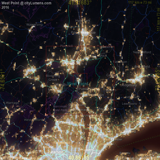
Analysis of West Point night lights 2016
Square area 10x10 km:
 0.51%
0.51%90-99
3.57%80-89
1.53%70-79
1.02%60-69
1.36%50-59
3.23%40-49
2.38%30-39
3.91%20-29
0.17%10-19
21.77%0-9
60.54%Square area 50x50 km:
1.5%90-99
2.1%80-89
3.08%70-79
3%60-69
3.02%50-59
3.58%40-49
4.48%30-39
5.22%20-29
9.22%10-19
23.13%0-9
41.65%Clear (daylight) street map image can be seen on geolist.org.
Map coordinates:
41° 55' 0.6" North, 74° 39' 32.8" West
41° 23' 29.3" North, 73° 57' 21.5" West
40° 51' 42.7" North, 73° 15' 10.3" West
Some cities around West Point sort by population:
• Newburgh
13.2 km =8.2 mi,  339°
339°
• Peekskill
11.7 km =7.3 mi,  165°
165°
• Beacon
12.7 km =7.9 mi,  354°
354°
• Jefferson Valley-Yorktown
15.3 km =9.5 mi,  122°
122°
• Woodbury
12.9 km =8 mi,  256°
256°
• New Windsor
11 km =6.8 mi,  329°
329°
• Lake Mohegan
12.3 km =7.6 mi,  131°
131°
• Washingtonville
18 km =11.2 mi,  283°
283°
5143966 (p: 6,763)
Sources (retrieved 2019-11-25):
» Earth at Night: Flat Maps 2012, 2016