Kiryas Joel night lights from space
Night Light of Kiryas Joel (New York) from space (United States) Src. Average luminocity for 10x10km area is 39.881% and for 50x50km: 23.1991%.
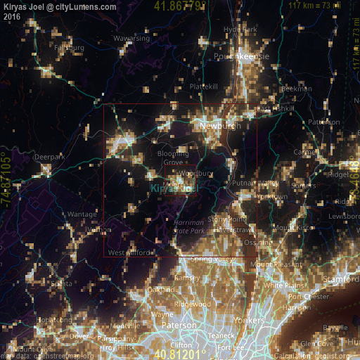

Analysis of Kiryas Joel night lights 2016
Square area 10x10 km:
 3.91%
3.91%90-99
3.23%80-89
3.91%70-79
7.14%60-69
7.82%50-59
6.8%40-49
11.22%30-39
7.82%20-29
13.1%10-19
29.76%0-9
5.27%Square area 50x50 km:
1.99%90-99
2.67%80-89
2.96%70-79
3.02%60-69
3.8%50-59
4.04%40-49
3.86%30-39
4.33%20-29
8.49%10-19
17.85%0-9
47%Clear (daylight) street map image can be seen on geolist.org.
Map coordinates:
41° 52' 4" North, 74° 52' 15.8" West
41° 20' 31.3" North, 74° 10' 4.5" West
40° 48' 43.2" North, 73° 27' 53.3" West
Some cities around Kiryas Joel sort by population:
• Woodbury
5.7 km =3.5 mi,  64°
64°
• New Windsor
19.2 km =11.9 mi,  38°
38°
• Monroe
2 km =1.2 mi,  231°
231°
• Warwick
18.6 km =11.6 mi,  239°
239°
• West Point
18.5 km =11.5 mi,  72°
72°
• Washingtonville
9.5 km =5.9 mi,  0°
0°
• Goshen
14.7 km =9.1 mi,  297°
297°
• Thiells
19.3 km =12 mi,  139°
139°
5123533 (p: 22,851)
Sources (retrieved 2019-11-25):
» Earth at Night: Flat Maps 2012, 2016