Washingtonville night lights from space
Night Light of Washingtonville (New York) from space (United States) Src. Average luminocity for 10x10km area is 14.4133% and for 50x50km: 20.5363%.
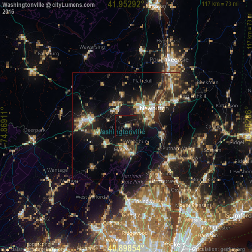
Analysis of Washingtonville night lights 2016
Square area 10x10 km:
 0%
0%90-99
0.68%80-89
3.23%70-79
1.53%60-69
1.36%50-59
0.34%40-49
1.53%30-39
2.21%20-29
1.53%10-19
23.81%0-9
63.78%Square area 50x50 km:
1.72%90-99
2.3%80-89
2.85%70-79
2.67%60-69
2.9%50-59
2.91%40-49
3.52%30-39
4.27%20-29
7.22%10-19
17.36%0-9
52.27%Clear (daylight) street map image can be seen on geolist.org.
Map coordinates:
41° 57' 10.5" North, 74° 52' 8.8" West
41° 25' 40.3" North, 74° 9' 57.5" West
40° 53' 54.7" North, 73° 27' 46.3" West
Some cities around Washingtonville sort by population:
• Newburgh
15.4 km =9.6 mi,  57°
57°
• Kiryas Joel
9.5 km =5.9 mi,  180°
180°
• Woodbury
8.6 km =5.3 mi,  144°
144°
• New Windsor
13 km =8.1 mi,  65°
65°
• Monroe
10.9 km =6.8 mi,  189°
189°
• Orange Lake
13.7 km =8.5 mi,  24°
24°
• Walden
14.9 km =9.3 mi,  352°
352°
• Goshen
13.5 km =8.4 mi,  257°
257°
5143344 (p: 5,788)
Sources (retrieved 2019-11-25):
» Earth at Night: Flat Maps 2012, 2016