Woodbridge night lights from space
Night Light of Woodbridge (Connecticut) from space (United States) Src. Average luminocity for 10x10km area is 38.6752% and for 50x50km: 36.9332%.
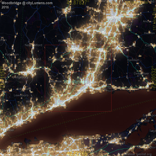
Analysis of Woodbridge night lights 2016
Square area 10x10 km:
 2.55%
2.55%90-99
6.12%80-89
3.57%70-79
4.93%60-69
4.59%50-59
4.93%40-49
8.84%30-39
12.59%20-29
24.66%10-19
25.51%0-9
1.7%Square area 50x50 km:
5.17%90-99
5.69%80-89
4.36%70-79
5%60-69
6.55%50-59
7.4%40-49
7.42%30-39
6.61%20-29
9.2%10-19
13.48%0-9
29.13%Clear (daylight) street map image can be seen on geolist.org.
Map coordinates:
41° 52' 41.8" North, 73° 42' 41.7" West
41° 21' 9.4" North, 73° 0' 30.4" West
40° 49' 21.6" North, 72° 18' 19.2" West
Some cities around Woodbridge sort by population:
• New Haven
8.3 km =5.2 mi,  126°
126°
• Hamden
10.5 km =6.5 mi,  62°
62°
• West Haven
10.5 km =6.5 mi,  150°
150°
• Shelton
8.1 km =5 mi,  240°
240°
• Ansonia
5.9 km =3.7 mi,  263°
263°
• Seymour
7.5 km =4.7 mi,  311°
311°
• Orange
8.4 km =5.2 mi,  189°
189°
• Derby
7.6 km =4.7 mi, 242°
4846022 (p: 9,355)
Sources (retrieved 2019-11-25):
» Earth at Night: Flat Maps 2012, 2016