Derby night lights from space
Night Light of Derby (Connecticut) from space (United States) Src. Average luminocity for 10x10km area is 50.0714% and for 50x50km: 33.5011%.
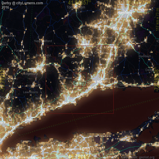
Analysis of Derby night lights 2016
Square area 10x10 km:
 4.59%
4.59%90-99
5.78%80-89
5.27%70-79
5.1%60-69
10.37%50-59
13.95%40-49
19.05%30-39
10.37%20-29
17.86%10-19
7.65%0-9
0%Square area 50x50 km:
4.37%90-99
4.85%80-89
4.04%70-79
4.35%60-69
5.97%50-59
6.88%40-49
6.66%30-39
6.24%20-29
8.77%10-19
14.03%0-9
33.84%Clear (daylight) street map image can be seen on geolist.org.
Map coordinates:
41° 50' 47.7" North, 73° 47' 31.7" West
41° 19' 14.3" North, 73° 5' 20.4" West
40° 47' 25.6" North, 72° 23' 9.2" West
Some cities around Derby sort by population:
• Milford
11.3 km =7 mi,  166°
166°
• City of Milford (balance)
11 km =6.8 mi, 168°
• Shelton
0.6 km =0.4 mi,  216°
216°
• Trumbull
12.7 km =7.9 mi,  227°
227°
• Ansonia
3 km =1.9 mi,  16°
16°
• Seymour
8.5 km =5.3 mi,  7°
7°
• Orange
7.1 km =4.4 mi,  131°
131°
• Woodbridge
7.6 km =4.7 mi,  62°
62°
4832745 (p: 12,700)
Sources (retrieved 2019-11-25):
» Earth at Night: Flat Maps 2012, 2016