Seymour night lights from space
Night Light of Seymour (Connecticut) from space (United States) Src. Average luminocity for 10x10km area is 28.8827% and for 50x50km: 36.5145%.
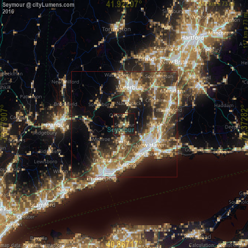
Analysis of Seymour night lights 2016
Square area 10x10 km:
 0.51%
0.51%90-99
0.68%80-89
3.4%70-79
4.93%60-69
3.74%50-59
5.44%40-49
6.46%30-39
5.95%20-29
18.88%10-19
42.69%0-9
7.31%Square area 50x50 km:
4.81%90-99
5.39%80-89
4.52%70-79
4.91%60-69
6.43%50-59
7.75%40-49
7.6%30-39
6.83%20-29
8.97%10-19
12.69%0-9
30.09%Clear (daylight) street map image can be seen on geolist.org.
Map coordinates:
41° 55' 19.5" North, 73° 46' 44.7" West
41° 23' 48.3" North, 73° 4' 33.4" West
40° 52' 1.8" North, 72° 22' 22.2" West
Some cities around Seymour sort by population:
• Shelton
9 km =5.6 mi,  189°
189°
• Naugatuck
10.1 km =6.3 mi,  11°
11°
• Ansonia
5.6 km =3.5 mi,  182°
182°
• Orange
13.8 km =8.6 mi,  162°
162°
• Derby
8.5 km =5.3 mi, 187°
• Oxford
5.4 km =3.4 mi,  320°
320°
• Prospect
14.3 km =8.9 mi,  34°
34°
• Woodbridge
7.5 km =4.7 mi,  131°
131°
4842818 (p: 16,562)
Sources (retrieved 2019-11-25):
» Earth at Night: Flat Maps 2012, 2016