Plainville night lights from space
Night Light of Plainville (Connecticut) from space (United States) Src. Average luminocity for 10x10km area is 66.5% and for 50x50km: 43.4141%.
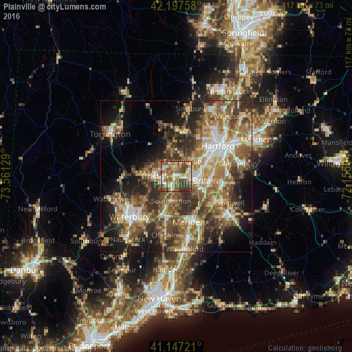
Analysis of Plainville night lights 2016
Square area 10x10 km:
 9.74%
9.74%90-99
11.69%80-89
9.25%70-79
10.88%60-69
13.8%50-59
20.78%40-49
11.53%30-39
11.85%20-29
0.49%10-19
0%0-9
0%Square area 50x50 km:
5.81%90-99
6.06%80-89
5.99%70-79
7.01%60-69
8.52%50-59
9.54%40-49
7.84%30-39
7.97%20-29
9.36%10-19
11.7%0-9
20.2%Clear (daylight) street map image can be seen on geolist.org.
Map coordinates:
42° 11' 51.3" North, 73° 33' 40.6" West
41° 40' 28.3" North, 72° 51' 29.4" West
41° 8' 50" North, 72° 9' 18.1" West
Some cities around Plainville sort by population:
• New Britain
6.7 km =4.2 mi,  102°
102°
• West Hartford
13.7 km =8.5 mi,  44°
44°
• Bristol
7.6 km =4.7 mi,  267°
267°
• Newington
11.5 km =7.1 mi,  76°
76°
• Farmington
5.5 km =3.4 mi,  23°
23°
• Wolcott
13.4 km =8.3 mi,  233°
233°
• Kensington
8.6 km =5.3 mi,  120°
120°
• Terryville
12.7 km =7.9 mi, 271°
4840767 (p: 17,328)
Sources (retrieved 2019-11-25):
» Earth at Night: Flat Maps 2012, 2016