Winters night lights from space
Night Light of Winters (California) from space (United States) Src. Average luminocity for 10x10km area is 6.289% and for 50x50km: 8.7026%.
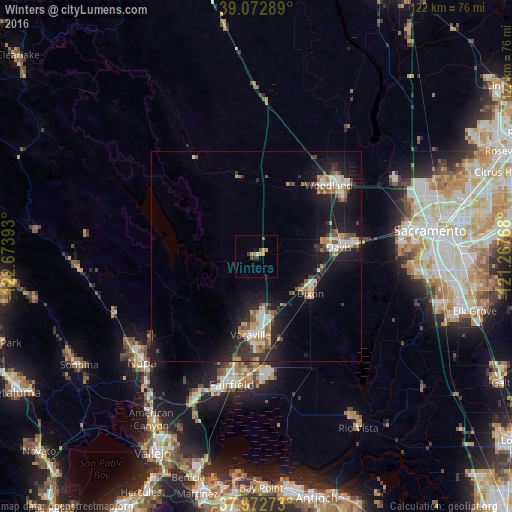
Analysis of Winters night lights 2016
Square area 10x10 km:
 0%
0%90-99
0.65%80-89
0%70-79
3.25%60-69
0.65%50-59
1.3%40-49
0.65%30-39
1.62%20-29
0.32%10-19
1.62%0-9
89.94%Square area 50x50 km:
1.19%90-99
1.18%80-89
0.59%70-79
1.43%60-69
0.99%50-59
1.17%40-49
1.3%30-39
1.1%20-29
2.44%10-19
8.74%0-9
79.86%Clear (daylight) street map image can be seen on geolist.org.
Map coordinates:
39° 4' 22.4" North, 122° 40' 26.1" West
38° 31' 29.7" North, 121° 58' 14.9" West
37° 58' 21.8" North, 121° 16' 3.6" West
Some cities around Winters sort by population:
• Fairfield
31.2 km =19.4 mi,  191°
191°
• Vacaville
18.8 km =11.7 mi,  184°
184°
• Napa
37.3 km =23.2 mi,  227°
227°
• Davis
20.2 km =12.6 mi,  83°
83°
• Woodland
24.2 km =15 mi,  45°
45°
• West Sacramento
38.8 km =24.1 mi, 80°
• Suisun
32.4 km =20.1 mi, 190°
• Dixon
15.6 km =9.7 mi,  124°
124°
5410125 (p: 7,034)
Sources (retrieved 2019-11-25):
» Earth at Night: Flat Maps 2012, 2016