Whiteville night lights from space
Night Light of Whiteville (North Carolina) from space (United States) Src. Average luminocity for 10x10km area is 34.4176% and for 50x50km: 4.4677%.
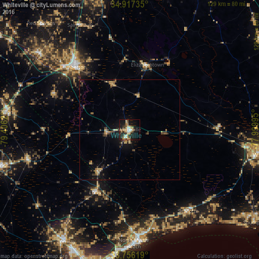
Analysis of Whiteville night lights 2016
Square area 10x10 km:
 4.4%
4.4%90-99
4.21%80-89
5.86%70-79
5.49%60-69
5.68%50-59
4.58%40-49
2.2%30-39
7.51%20-29
7.88%10-19
29.67%0-9
22.53%Square area 50x50 km:
0.2%90-99
0.24%80-89
0.81%70-79
0.76%60-69
0.65%50-59
0.45%40-49
0.66%30-39
1.24%20-29
1.09%10-19
3.12%0-9
90.78%Clear (daylight) street map image can be seen on geolist.org.
Map coordinates:
34° 55' 2.5" North, 79° 24' 22.3" West
34° 20' 19.6" North, 78° 42' 11.1" West
33° 45' 22.3" North, 77° 59' 59.8" West
Some cities around Whiteville sort by population:
• Lumberton
42 km =26.1 mi,  317°
317°
• Conway
64.3 km =40 mi,  209°
209°
• Leland
61.2 km =38 mi,  98°
98°
• North Myrtle Beach
58.2 km =36.2 mi,  177°
177°
• Red Hill
63.5 km =39.5 mi,  233°
233°
• Little River
52.4 km =32.6 mi,  171°
171°
• Marion
66.5 km =41.3 mi,  254°
254°
• Dillon
61.9 km =38.5 mi,  278°
278°
4498899 (p: 5,589)
Sources (retrieved 2019-11-25):
» Earth at Night: Flat Maps 2012, 2016