White Bear Lake night lights from space
Night Light of White Bear Lake (Minnesota) from space (United States) Src. Average luminocity for 10x10km area is 45.8288% and for 50x50km: 41.0237%.
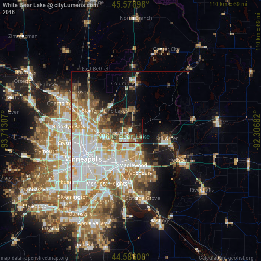

Analysis of White Bear Lake night lights 2016
Square area 10x10 km:
 5.61%
5.61%90-99
8.03%80-89
4.09%70-79
6.06%60-69
7.12%50-59
10.3%40-49
8.79%30-39
9.39%20-29
18.94%10-19
15%0-9
6.67%Square area 50x50 km:
12.55%90-99
9.49%80-89
4.22%70-79
4.94%60-69
5.93%50-59
4.17%40-49
4.27%30-39
2.53%20-29
4.05%10-19
10.17%0-9
37.68%Clear (daylight) street map image can be seen on geolist.org.
Map coordinates:
45° 34' 44.3" North, 93° 42' 47.1" West
45° 5' 4.9" North, 93° 0' 35.8" West
44° 35' 9.9" North, 92° 18' 24.6" West
Some cities around White Bear Lake sort by population:
• Shoreview
10.8 km =6.7 mi,  266°
266°
• Lino Lakes
10.4 km =6.5 mi,  323°
323°
• Hugo
8.5 km =5.3 mi,  8°
8°
• Vadnais Heights
5.9 km =3.7 mi,  238°
238°
• North Saint Paul
8.2 km =5.1 mi,  169°
169°
• Little Canada
8.9 km =5.5 mi,  223°
223°
• Arden Hills
12.1 km =7.5 mi,  251°
251°
• Mahtomedi
4.9 km =3 mi,  110°
110°
5052658 (p: 25,205)
Sources (retrieved 2019-11-25):
» Earth at Night: Flat Maps 2012, 2016