Vadnais Heights night lights from space
Night Light of Vadnais Heights (Minnesota) from space (United States) Src. Average luminocity for 10x10km area is 70.5803% and for 50x50km: 51.0957%.
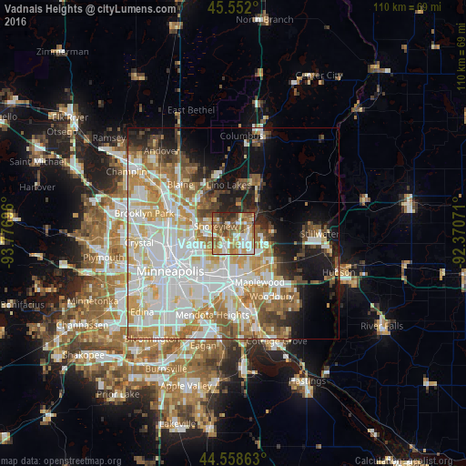
Analysis of Vadnais Heights night lights 2016
Square area 10x10 km:
 14.7%
14.7%90-99
15.3%80-89
6.52%70-79
15.61%60-69
14.85%50-59
13.48%40-49
8.33%30-39
4.09%20-29
7.12%10-19
0%0-9
0%Square area 50x50 km:
15.49%90-99
12.63%80-89
5.89%70-79
6.9%60-69
7.09%50-59
4.89%40-49
4.64%30-39
2.69%20-29
4.47%10-19
9.27%0-9
26.05%Clear (daylight) street map image can be seen on geolist.org.
Map coordinates:
45° 33' 7.2" North, 93° 46' 37.1" West
45° 3' 26.9" North, 93° 4' 25.8" West
44° 33' 31.1" North, 92° 22' 14.6" West
Some cities around Vadnais Heights sort by population:
• Roseville
8.7 km =5.4 mi,  228°
228°
• Shoreview
6.2 km =3.9 mi,  292°
292°
• White Bear Lake
5.9 km =3.7 mi,  58°
58°
• New Brighton
10.1 km =6.3 mi,  275°
275°
• North Saint Paul
8.2 km =5.1 mi,  127°
127°
• Little Canada
3.6 km =2.2 mi,  197°
197°
• Arden Hills
6.6 km =4.1 mi,  262°
262°
• Mahtomedi
9.7 km =6 mi,  81°
81°
5051197 (p: 13,266)
Sources (retrieved 2019-11-25):
» Earth at Night: Flat Maps 2012, 2016