Mahtomedi night lights from space
Night Light of Mahtomedi (Minnesota) from space (United States) Src. Average luminocity for 10x10km area is 27.9409% and for 50x50km: 35.9876%.
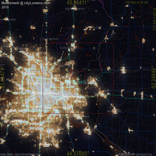
Analysis of Mahtomedi night lights 2016
Square area 10x10 km:
 2.27%
2.27%90-99
3.18%80-89
2.42%70-79
1.82%60-69
6.21%50-59
6.36%40-49
4.7%30-39
7.12%20-29
13.03%10-19
20%0-9
32.88%Square area 50x50 km:
10.17%90-99
7.83%80-89
3.39%70-79
4.43%60-69
5.89%50-59
4.29%40-49
4.15%30-39
2.51%20-29
4.02%10-19
10%0-9
43.31%Clear (daylight) street map image can be seen on geolist.org.
Map coordinates:
45° 33' 50.8" North, 93° 39' 17" West
45° 4' 10.9" North, 92° 57' 5.8" West
44° 34' 15.4" North, 92° 14' 54.5" West
Some cities around Mahtomedi sort by population:
• Oakdale
11.9 km =7.4 mi,  185°
185°
• White Bear Lake
4.9 km =3 mi,  290°
290°
• Stillwater
11.5 km =7.1 mi,  97°
97°
• Hugo
10.6 km =6.6 mi,  341°
341°
• Vadnais Heights
9.7 km =6 mi,  261°
261°
• North Saint Paul
7.1 km =4.4 mi,  206°
206°
• Little Canada
11.7 km =7.3 mi,  246°
246°
• Lake Elmo
10 km =6.2 mi,  145°
145°
5036295 (p: 8,116)
Sources (retrieved 2019-11-25):
» Earth at Night: Flat Maps 2012, 2016