Wheelersburg night lights from space
Night Light of Wheelersburg (Ohio) from space (United States) Src. Average luminocity for 10x10km area is 25.2925% and for 50x50km: 7.849%.
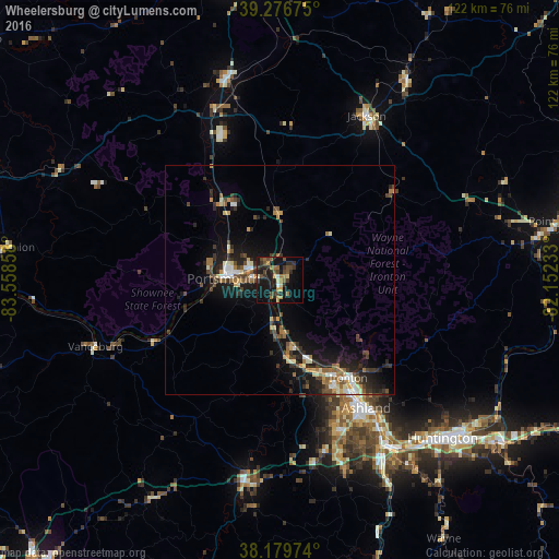
Analysis of Wheelersburg night lights 2016
Square area 10x10 km:
 0.85%
0.85%90-99
2.04%80-89
1.87%70-79
4.42%60-69
5.61%50-59
2.89%40-49
7.31%30-39
5.78%20-29
4.25%10-19
35.2%0-9
29.76%Square area 50x50 km:
0.54%90-99
1.13%80-89
0.57%70-79
0.97%60-69
1.19%50-59
1.08%40-49
1.71%30-39
1.59%20-29
2.33%10-19
6.92%0-9
81.98%Clear (daylight) street map image can be seen on geolist.org.
Map coordinates:
39° 16' 36.3" North, 83° 33' 30.9" West
38° 43' 49.3" North, 82° 51' 19.6" West
38° 10' 47.1" North, 82° 9' 8.4" West
Some cities around Wheelersburg sort by population:
• Meads
37.6 km =23.4 mi,  160°
160°
• Ironville
33.6 km =20.9 mi, 155°
• Huntington
49.7 km =30.9 mi,  134°
134°
• Ashland
33.8 km =21 mi,  145°
145°
• Portsmouth
12.3 km =7.6 mi,  270°
270°
• Ironton
26.2 km =16.3 mi, 145°
• Flatwoods
26 km =16.2 mi, 152°
• Jackson
40.5 km =25.2 mi,  27°
27°
4528203 (p: 6,437)
Sources (retrieved 2019-11-25):
» Earth at Night: Flat Maps 2012, 2016