Flatwoods night lights from space
Night Light of Flatwoods (Kentucky) from space (United States) Src. Average luminocity for 10x10km area is 54.0942% and for 50x50km: 16.6689%.
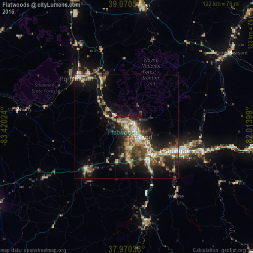
Analysis of Flatwoods night lights 2016
Square area 10x10 km:
 8.12%
8.12%90-99
13.31%80-89
4.38%70-79
6.82%60-69
11.04%50-59
12.34%40-49
4.06%30-39
8.77%20-29
14.94%10-19
14.94%0-9
1.3%Square area 50x50 km:
1.62%90-99
2.64%80-89
1.54%70-79
1.94%60-69
2.61%50-59
2.82%40-49
3.51%30-39
3.96%20-29
5.03%10-19
10.57%0-9
63.76%Clear (daylight) street map image can be seen on geolist.org.
Map coordinates:
39° 4' 14.1" North, 83° 25' 12.9" West
38° 31' 21.3" North, 82° 43' 1.6" West
37° 58' 13.4" North, 82° 0' 50.4" West
Some cities around Flatwoods sort by population:
• Meads
12.3 km =7.6 mi,  176°
176°
• Ironville
7.7 km =4.8 mi,  163°
163°
• Huntington
26.3 km =16.3 mi,  115°
115°
• Ashland
8.5 km =5.3 mi,  125°
125°
• Portsmouth
33.7 km =20.9 mi,  313°
313°
• Ironton
3.4 km =2.1 mi,  62°
62°
• Pea Ridge
36.6 km =22.7 mi,  109°
109°
• Wheelersburg
26 km =16.2 mi,  332°
332°
4291884 (p: 7,335)
Sources (retrieved 2019-11-25):
» Earth at Night: Flat Maps 2012, 2016