Ironton night lights from space
Night Light of Ironton (Ohio) from space (United States) Src. Average luminocity for 10x10km area is 51.9123% and for 50x50km: 17.3806%.
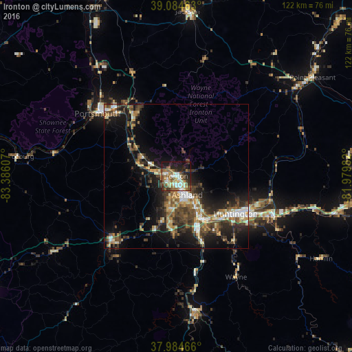
Analysis of Ironton night lights 2016
Square area 10x10 km:
 8.12%
8.12%90-99
12.18%80-89
3.73%70-79
6.66%60-69
8.6%50-59
13.15%40-49
6.17%30-39
7.79%20-29
13.96%10-19
17.37%0-9
2.27%Square area 50x50 km:
1.71%90-99
2.87%80-89
1.7%70-79
1.98%60-69
2.69%50-59
2.84%40-49
3.68%30-39
4.07%20-29
5.41%10-19
10.8%0-9
62.25%Clear (daylight) street map image can be seen on geolist.org.
Map coordinates:
39° 5' 4.7" North, 83° 23' 9.9" West
38° 32' 12.3" North, 82° 40' 58.6" West
37° 59' 4.8" North, 81° 58' 47.4" West
Some cities around Ironton sort by population:
• Meads
14 km =8.7 mi,  189°
189°
• Ironville
9 km =5.6 mi, 185°
• Huntington
24.5 km =15.2 mi,  122°
122°
• Ashland
7.6 km =4.7 mi,  148°
148°
• Portsmouth
34.9 km =21.7 mi,  308°
308°
• Flatwoods
3.4 km =2.1 mi,  242°
242°
• Pea Ridge
34.4 km =21.4 mi,  113°
113°
• Wheelersburg
26.2 km =16.3 mi,  325°
325°
4515247 (p: 10,900)
Sources (retrieved 2019-11-25):
» Earth at Night: Flat Maps 2012, 2016