West Slope night lights from space
Night Light of West Slope (Oregon) from space (United States) Src. Average luminocity for 10x10km area is 82.7651% and for 50x50km: 44.9366%.
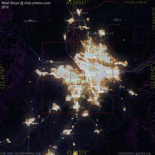
Analysis of West Slope night lights 2016
Square area 10x10 km:
 21.27%
90-99
20.16%80-89
12.7%70-79
22.86%60-69
18.57%50-59
2.86%40-49
1.59%30-39
0%20-29
0%10-19
0%0-9
0%Square area 50x50 km:
11.77%90-99
12.3%80-89
5.53%70-79
5.8%60-69
5.39%50-59
4.57%40-49
3.29%30-39
3.41%20-29
6.09%10-19
11.13%0-9
30.72%Clear (daylight) street map image can be seen on geolist.org.
Map coordinates:
45° 59' 21.9" North, 123° 28' 3.6" West
45° 29' 55.4" North, 122° 45' 52.3" West
45° 0' 13.5" North, 122° 3' 41.1" West
Some cities around West Slope sort by population:
• Portland
7.4 km =4.6 mi,  68°
68°
• Beaverton
3.3 km =2.1 mi,  246°
246°
• Tigard
7.5 km =4.7 mi,  184°
184°
• Cedar Mill
4.6 km =2.9 mi,  308°
308°
• Oak Hills
7.6 km =4.7 mi, 308°
• Cedar Hills
2.7 km =1.7 mi,  284°
284°
• Garden Home-Whitford
3.9 km =2.4 mi,  173°
173°
• Raleigh Hills
2 km =1.2 mi, 174°
5760068 (p: 6,554)
Sources (retrieved 2019-11-25):
» Earth at Night: Flat Maps 2012, 2016