Cedar Hills night lights from space
Night Light of Cedar Hills (Oregon) from space (United States) Src. Average luminocity for 10x10km area is 86.6302% and for 50x50km: 43.7288%.
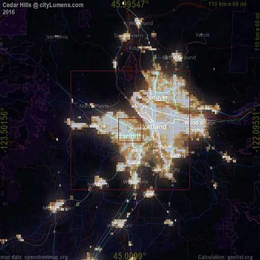
Analysis of Cedar Hills night lights 2016
Square area 10x10 km:
 27.94%
90-99
23.49%80-89
17.14%70-79
17.78%60-69
9.52%50-59
1.43%40-49
2.7%30-39
0%20-29
0%10-19
0%0-9
0%Square area 50x50 km:
11.59%90-99
12.02%80-89
5.37%70-79
5.72%60-69
5.09%50-59
4.4%40-49
2.97%30-39
3.38%20-29
5.88%10-19
10.86%0-9
32.72%Clear (daylight) street map image can be seen on geolist.org.
Map coordinates:
45° 59' 43.7" North, 123° 30' 5.6" West
45° 30' 17.4" North, 122° 47' 54.3" West
45° 0' 35.6" North, 122° 5' 43.1" West
Some cities around Cedar Hills sort by population:
• Beaverton
2 km =1.2 mi,  191°
191°
• Aloha
5.5 km =3.4 mi,  257°
257°
• Oak Hills
5.2 km =3.2 mi,  320°
320°
• West Haven-Sylvan
2.7 km =1.7 mi,  62°
62°
• Garden Home-Whitford
5.5 km =3.4 mi,  145°
145°
• West Slope
2.7 km =1.7 mi,  104°
104°
• West Haven
2.7 km =1.7 mi, 57°
• Raleigh Hills
3.9 km =2.4 mi,  133°
133°
5718480 (p: 8,300)
Sources (retrieved 2019-11-25):
» Earth at Night: Flat Maps 2012, 2016