Raleigh Hills night lights from space
Night Light of Raleigh Hills (Oregon) from space (United States) Src. Average luminocity for 10x10km area is 85.1841% and for 50x50km: 44.6389%.
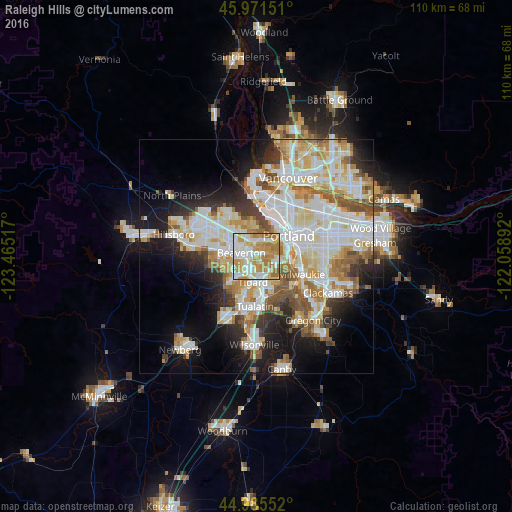
Analysis of Raleigh Hills night lights 2016
Square area 10x10 km:
 24.6%
24.6%90-99
22.38%80-89
13.02%70-79
23.65%60-69
15.56%50-59
0.79%40-49
0%30-39
0%20-29
0%10-19
0%0-9
0%Square area 50x50 km:
11.81%90-99
12.26%80-89
5.49%70-79
5.74%60-69
5.27%50-59
4.5%40-49
3.22%30-39
3.25%20-29
5.81%10-19
11.25%0-9
31.4%Clear (daylight) street map image can be seen on geolist.org.
Map coordinates:
45° 58' 17.4" North, 123° 27' 54.6" West
45° 28' 50.4" North, 122° 45' 43.3" West
44° 59' 7.9" North, 122° 3' 32.1" West
Some cities around Raleigh Hills sort by population:
• Beaverton
3.3 km =2.1 mi,  282°
282°
• Tigard
5.5 km =3.4 mi,  187°
187°
• Cedar Mill
6.2 km =3.9 mi,  322°
322°
• Cedar Hills
3.9 km =2.4 mi,  313°
313°
• West Haven-Sylvan
4 km =2.5 mi,  353°
353°
• Garden Home-Whitford
1.9 km =1.2 mi,  172°
172°
• West Slope
2 km =1.2 mi, 354°
• West Haven
4.1 km =2.5 mi, 351°
5747420 (p: 5,896)
Sources (retrieved 2019-11-25):
» Earth at Night: Flat Maps 2012, 2016