Oak Hills night lights from space
Night Light of Oak Hills (Oregon) from space (United States) Src. Average luminocity for 10x10km area is 76.7258% and for 50x50km: 40.1%.
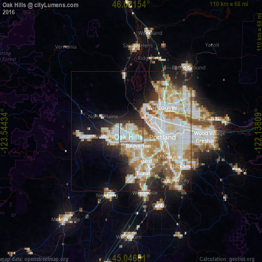
Analysis of Oak Hills night lights 2016
Square area 10x10 km:
 24.55%
90-99
27.12%80-89
9.7%70-79
9.09%60-69
2.42%50-59
3.48%40-49
1.06%30-39
13.94%20-29
8.64%10-19
0%0-9
0%Square area 50x50 km:
10.68%90-99
10.96%80-89
5.04%70-79
5.47%60-69
4.61%50-59
3.71%40-49
2.63%30-39
2.96%20-29
5.92%10-19
9.15%0-9
38.86%Clear (daylight) street map image can be seen on geolist.org.
Map coordinates:
46° 1' 53.5" North, 123° 32' 39.6" West
45° 32' 28.4" North, 122° 50' 28.4" West
45° 2' 47.8" North, 122° 8' 17.1" West
Some cities around Oak Hills sort by population:
• Beaverton
6.7 km =4.2 mi,  154°
154°
• Aloha
5.6 km =3.5 mi,  201°
201°
• Bethany
2.8 km =1.7 mi,  312°
312°
• Cedar Mill
3 km =1.9 mi,  127°
127°
• Rockcreek
3 km =1.9 mi,  289°
289°
• Cedar Hills
5.2 km =3.2 mi,  140°
140°
• West Haven-Sylvan
6.3 km =3.9 mi,  116°
116°
• West Haven
6.2 km =3.9 mi, 115°
5743753 (p: 11,333)
Sources (retrieved 2019-11-25):
» Earth at Night: Flat Maps 2012, 2016