West Rancho Dominguez night lights from space
Night Light of West Rancho Dominguez (California) from space (United States) Src. Average luminocity for 10x10km area is 99.9545% and for 50x50km: 72.9778%.
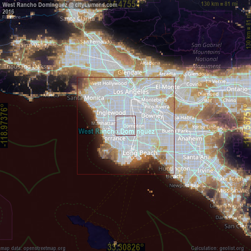
Analysis of West Rancho Dominguez night lights 2016
Square area 10x10 km:
 95.8%
95.8%90-99
4.2%80-89
0%70-79
0%60-69
0%50-59
0%40-49
0%30-39
0%20-29
0%10-19
0%0-9
0%Square area 50x50 km:
44.03%90-99
17.02%80-89
3.76%70-79
3.18%60-69
3.41%50-59
2.44%40-49
2.04%30-39
1.84%20-29
3.33%10-19
4.49%0-9
14.46%Clear (daylight) street map image can be seen on geolist.org.
Map coordinates:
34° 28' 31.9" North, 118° 58' 25.5" West
33° 53' 38" North, 118° 16' 14.3" West
33° 18' 29.7" North, 117° 34' 3" West
Some cities around West Rancho Dominguez sort by population:
• Compton
4.7 km =2.9 mi,  87°
87°
• Carson
7 km =4.3 mi,  188°
188°
• Lynwood
6.8 km =4.2 mi,  53°
53°
• Gardena
3.6 km =2.2 mi,  260°
260°
• Willowbrook
2.9 km =1.8 mi,  29°
29°
• Westmont
6 km =3.7 mi,  331°
331°
• East Rancho Dominguez
7 km =4.3 mi, 86°
• Alondra Park
5.6 km =3.5 mi, 264°
5407927 (p: 5,669)
Sources (retrieved 2019-11-25):
» Earth at Night: Flat Maps 2012, 2016