East Rancho Dominguez night lights from space
Night Light of East Rancho Dominguez (California) from space (United States) Src. Average luminocity for 10x10km area is 99.8969% and for 50x50km: 83.6845%.
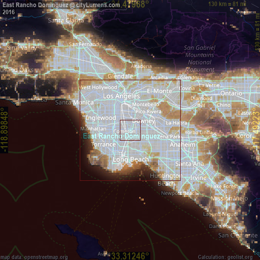
Analysis of East Rancho Dominguez night lights 2016
Square area 10x10 km:
 90.91%
90-99
9.09%80-89
0%70-79
0%60-69
0%50-59
0%40-49
0%30-39
0%20-29
0%10-19
0%0-9
0%Square area 50x50 km:
49.41%90-99
21.42%80-89
5.2%70-79
4.29%60-69
3.43%50-59
2.02%40-49
1.54%30-39
1.35%20-29
2.55%10-19
3.61%0-9
5.19%Clear (daylight) street map image can be seen on geolist.org.
Map coordinates:
34° 28' 46.8" North, 118° 53' 54.5" West
33° 53' 53.1" North, 118° 11' 43.3" West
33° 18' 44.9" North, 117° 29' 32" West
Some cities around East Rancho Dominguez sort by population:
• Downey
7.4 km =4.6 mi,  51°
51°
• Compton
2.3 km =1.4 mi,  263°
263°
• South Gate
6.5 km =4 mi,  346°
346°
• Lynwood
3.9 km =2.4 mi,  337°
337°
• Paramount
3.4 km =2.1 mi,  106°
106°
• Willowbrook
5.9 km =3.7 mi,  290°
290°
• Cudahy
7 km =4.3 mi,  7°
7°
• West Rancho Dominguez
7 km =4.3 mi,  266°
266°
5344817 (p: 15,135)
Sources (retrieved 2019-11-25):
» Earth at Night: Flat Maps 2012, 2016