Lake Saint Louis night lights from space
Night Light of Lake Saint Louis (Missouri) from space (United States) Src. Average luminocity for 10x10km area is 71.6684% and for 50x50km: 26.2901%.
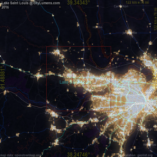
Analysis of Lake Saint Louis night lights 2016
Square area 10x10 km:
 11.22%
90-99
12.24%80-89
16.84%70-79
14.63%60-69
15.99%50-59
11.05%40-49
10.37%30-39
4.76%20-29
2.89%10-19
0%0-9
0%Square area 50x50 km:
3.36%90-99
3.75%80-89
4.31%70-79
5.16%60-69
5.68%50-59
4%40-49
2.44%30-39
4.36%20-29
4.69%10-19
9.4%0-9
52.86%Clear (daylight) street map image can be seen on geolist.org.
Map coordinates:
39° 20' 36.3" North, 91° 29' 19.7" West
38° 47' 51.2" North, 90° 47' 8.4" West
38° 14' 50.9" North, 90° 4' 57.2" West
Some cities around Lake Saint Louis sort by population:
• O'Fallon
7.6 km =4.7 mi,  78°
78°
• Saint Peters
13.8 km =8.6 mi,  88°
88°
• Chesterfield
23.5 km =14.6 mi,  129°
129°
• Wildwood
26.1 km =16.2 mi,  155°
155°
• Wentzville
6 km =3.7 mi,  284°
284°
• Dardenne Prairie
5.8 km =3.6 mi,  122°
122°
• Troy
26.3 km =16.3 mi,  320°
320°
• Weldon Spring
12.5 km =7.8 mi,  138°
138°
4394302 (p: 14,545)
Sources (retrieved 2019-11-25):
» Earth at Night: Flat Maps 2012, 2016